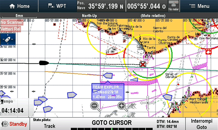
The AIS – Automatic Identification System is a fundamental tool for maritime safety. Designed for locating and identifying vessels, it allows the display of nearby ships on a dedicated screen or chartplotter, with crucial details such as MMSI, position, course, speed, and other useful data to prevent collisions. The AIS – Automatic Identification System is mandatory for all cargo ships with a gross tonnage (GT) exceeding 300 tons and for passenger vessels. In the recreational boating sector, however, its use is optional but increasingly widespread due to its advantages in terms of safety and situational awareness.
What is AIS – Automatic Identification System?
The Automatic Identification System (AIS) is a radio system used to monitor maritime traffic. It transmits and receives data via VHF, allowing vessels to view ships in real-time within a radius of about 20 nautical miles. Among its main advantages, AIS improves navigation safety by reducing the risk of collisions, especially in conditions of reduced visibility or in high-traffic areas.
AIS Classes: Class A and Class B
The AIS – Automatic Identification System is available in two main classes:
AIS Class A
Mandatory for all vessels subject to IMO/SOLAS regulations (such as cargo ships over 300 GT and passenger ships), AIS Class A operates on dual frequency and has a range of about 20 nautical miles. It continuously transmits detailed and updated information about its position and movement.
AIS Class B
Intended for recreational boats and vessels not subject to IMO/SOLAS, AIS Class B is available in two versions:
-
Receive-only, single frequency.
-
Receive and transmit, dual frequency, with transmission power up to 2 Watts and coverage between 5 and 10 nautical miles.
In recreational boating, AIS can be integrated into the VHF or installed as a separate unit, with a dedicated antenna on the rollbar or connected to the VHF antenna at the masthead via a splitter – a solution that improves range and performance.
What data does AIS transmit and receive?
The AIS – Automatic Identification System allows the automatic exchange of multiple identifying and navigational data, including:
-
Vessel position (via GPS)
-
Speed and course
-
MMSI (Maritime Mobile Service Identity)
-
Call sign
-
Vessel name
-
Destination
-
Vessel status (underway or moored)
Thanks to this information, the chartplotter can calculate:
-
CPA (Closest Point of Approach): predicted minimum distance between two vessels.
-
TCPA (Time to Closest Point of Approach): predicted time to reach the CPA.
These values are fundamental for preventing collisions and setting up safety alarms on board.
AIS as a navigation aid
In addition to vessels, the AIS – Automatic Identification System can be used to transmit data on fixed or floating objects, such as:
-
Lighthouses
-
Buoys
-
Beacons
-
Coastal markers
This gives rise to the concept of Virtual AIS (also called Synthetic AIS or Artificial AIS), which allows:
-
The transmission of a physical object’s position via a remote transmitter (e.g., a coastal station).
-
The signaling of dangers not physically present, such as submerged wrecks or invisible obstacles.
These virtual aids are only visible to those using an active AIS receiver.
AIS for safety: the MOB example
The AIS – Automatic Identification System is also useful in emergency situations. For example, in case of a man overboard (MOB – Man Overboard), an AIS Beacon worn by the crew can automatically transmit the position of the person who fell into the water, displaying it on the chartplotter and facilitating recovery. Other nearby vessels equipped with AIS can also receive the signal, increasing the chances of rescue.
Limitations of the AIS system
The effectiveness of the AIS – Automatic Identification System depends on the presence of an active transmitter on board. If a vessel is not equipped with AIS, or if the system is malfunctioning, it will not be visible. It’s important to remember that AIS is an aid, not an infallible system.
For greater safety, it is advisable to use radar alongside AIS, particularly useful at night or in conditions of reduced visibility. Radar and AIS complement each other, offering a broader and more detailed view of maritime traffic.
Conclusion
The AIS – Automatic Identification System is today one of the most effective tools for improving safety at sea, both for commercial navigation and leisure boating. However, the ultimate responsibility always lies with the captain, who must maintain constant visual vigilance and take all necessary measures to avoid accidents.
Subscribe to the Yamana Sailing Life newsletter to receive more useful insights on navigation, safety at sea, and onboard technologies!


